
ROUTE MAPPING THE MAN MADE FLOODS IN LAGOS
1.0 ESCAPING FROM THE MAN MADE FLOOD IN LAGOS

1.1 INTRODUCTION -
 Lagos - In The Pre and post independence period of Nigeria the economical development & migration of people had developed lagos as largest metropolitan area in Africa. Lagos is a major African financial centre and is the economic hub of Lagos State and Nigeria as well . Lagos becpme the port city of Nigeria and as years passed the expansion of lagos to west and fast urbanization experienced rapid growth throughout the 1960s and 1970s as a result of Nigeria's economic boom made two areas in lagos as Main land and islands and three major bridges join the island to the mainland. They are the 1. Carter Bridge, which starts from Iddo , 2. the Eko Bridge (formerly called the Second Mainland Bridge); and 3. the Third Mainland Bridge, which passes through densely populated mainland suburbs to the Lagos Lagoon. 4. The Ikoyi link bridge links Ikoyi and Lekki Phase 1, both of which are part of the Island had developed lagos one of the biggest city in Africa and as years passed lagos played the dual role of being the State and Federal Capital until 1976 when the state capital was moved to Ikeja and was the national capital of Nigeria until December 1991 till the Nigerian country capital become Abuja.
 In pre independence period Railway links and telephone cables connecting Lagos to London had been established by 1886 . Electric street lighting was introduced in the city in 1896 and large number ports along the coast , Airport , roads , industry the Lagos experienced rapid growth throughout the 1960s and 1970s as a result of Nigeria's economic boom.
The rapid grouth and urbanization had made negative impacts to the city when the natural hazards and crisis like flash floods create panic in public due to intense rains made the rivers and dams to overflow and the free flow of water is blocked due to waste dumbing and building as a part of urbanization resulting floods in city streets made lot of people to die, relocate to higher lands , damage to house and properties .
The rapid urbanization and to minimize the large impacts of floods in city street the Urban planning and Architecture Design for Sustainable development is implementing in lagos metropolitan city as a solution to all these problems for future development
1.2 LIVING ON THE EDGES
 The Man Made Flooding had worsen the Flood crisis in Nigeria major urban land that made disasters in Lagos city .
The Many places of Africa are in floods in the last many years that affects the inhabitants , live stocks property made them to relocate to other places or camps in the urban cities of Nigeria like the lagos and its peripherals.
The flood crisis in Lagos is due to heavy torrential rains , Storms , Slurry filled poor drainage ways , poor urbanization & Urbanized build up landscape, Anthropogenic Activities, Winds & Sea erosion , High tide waves & sea rises , climatic changes , waste disposal, pre and post Cyclone flooding Assessment planning , shortage food and water in flood affected areas, intense release of water from ogun Osun Dams & Oyan River dam to adjourned area in lagos, blockage of water due to dumping waste and blocked narrow streams made flood like sitwation very fast in street of lagos in raining
The impacts of Flooding in Lagos had affected people due to disrupted Public transport as roads & rails are flooded , Destruction of houses , debris of flooded vehicles , Dead in flood waters, Accident in flood waters , poor drainage connection , Spread of diseases , shortage of relief materials foods and medicines, Destruction of crops and cutivation land is rising year by year made lot of preventive measures by urban planning & Architecture design for sustainable developments
Urban Planning & Architecture design for sustainable development is the fastest & easy way to develop the country from flood hazards by Intergrated mapping . The concept of Sustainable development in cities has become a requirement for Urban planning that involve development & design of land use in the Urban development projects 2022 . Like Lagos Nigeria , many cities like Zambia that is promoting Urban sustainable development with respect to the landscape is a solution to the Urban cities flood crisis where there is large population and population density also high in many parts of cities .
THE URBAN PLANNING PROJECT TO BE IMPLEMENTED TO OVERCOME THIS FLOOD CRISIS STE AS FOLLOWD
1. 1.3 SMART & COMPACT CITY URBAN PLANNING
2. 1.4 URBAN PLANNING in Urban low level lands that floods making the Smart & compact city
3. 1.5 Intergrated Underground Drainage ways in lagos developing a smart & compact city
4. 1.6 Urban planning coastline is making the Smart & compact city
5. 1.7 Flood resistant Urban houses is making the Smart & compact city
6. 1.8 Power Generation in building and house is making the Smart & compact city
7. 1.9 Developing Over flowing rivers banks , bridges under water and washed away roads is making the Smart & compact city
8. 2.0 Internet connectivity and Telecommunication TV program telecasting
The ways to overcome floods facts details & data in brief summary is given below
1.3 SMART & COMPACT CITY URBAN PLANNING

SMART CITY URBAN planning is developing a place from flood impacts . The Smart city project can be useful to save people from floods and deaths . in this i selected fue topics so that overflown dams water cannot make severe floods down streams as the excess water are open to sea by Underground drainage and other architecture topics like new model house with solar cell and wind blades for power generation as given below makes a smart and compact city
1.4 URBAN PLANNING in Urban low level lands that floods making the Smart & compact city
 LAGOS URBAN PLANNING & ARCHITECTURE DESIGN FOR SUSTANABLE DEVELOPMENT is covertion of lagos city maps to large image maps , 3 D Maps , digitial maps that gives a solution to the flood crisis by GIS. The over exploitation of Lagos land scape had given rise to large scale distruction in floods is on the large density of population rise , mining and destroying the river deta and water ways for the infrastructure development of the city had resulted floodimg to months from june to October as the goverment cannot take effective measures as the flood water is not receding from streets of the lagos after days of rain .
 In 2021 floods when the dams are opened , the people are told to evacuate and move to higher lands for their safety as water released from dams can overflow the rivers and floods the streets of lagos as the maps shows the extend of damages caused by floods due to urbanization and direction of water flow to lower lands of lagos . This flooding of lower land area of lagos consist of coastline , island , city streets and cultivated land
 Urban planning maps shows the land scape of lagos low level and high level land . Developing the drainage in low level land can reduce the intense of floods in the streets of lagos by constructing more number Underground drainage ways in low level , doing maintainence work of drainage ways every yearly and inspection of drainage to remove the slurry that block the drainage by waste dumping . Direct pipe drainage from dams like pier to pier pipe line so that unwanted water can be pumped out by pipes not by the rivers and canals
1.5 Intergrated Underground Drainage ways in lagos developing a smart & compact city
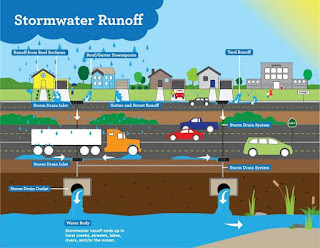
 integrated Underground Drainage way can save a metropolitan city from Floods . In Developed city of london , intergrated Underground Drainage ways are build beneath the roads , railway , airport , street and building so that drainage water are washed out by tunnel drainage ways and water pressure is reduced . The network of the drainage shows a large number of small tunnel ways is connected to a major big tunnel drainage way to the sea and this kind of underground drainage ways beneath the streets of lagos , below the road network , railway network , airport and mega grounds can control the floods as water assembled in places in raining cannot be blocked as they are opened to underground drainage network pipe lines in low level lands that inturn reduces the water in higher land area
1.6 Urban planning coastline is making the Smart & compact city
 Coastline of lagos is flooded as the sea level rises . The Sea wall construction in beaches and coastline can reduce the impacts high waves and the extend of damages as higher waves can wash away buiding in inner lands . intergrated Mapping the islands and coastline and resources of city can show the waves height and the extend of damages by images of coastline by urban planning
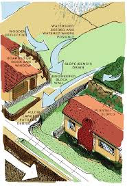
1.7 Flood resistant Urban houses is making the Smart & compact city
 New model flood resistant houses are developed so that water cannot flood the house as houses are lifted up as flood water rises is the floating house. The other houses are elevated houses where the house , building are elevated from ground level to a height on pillars so that eater risen flows below the house and not flood the houses snd building is the elevated housed . Other house are developed like movable house as these house are like carsvan that is movable from one place to other by vehicles .

1.8 Power Generation in building and house is making the Smart & compact city
 Power Generation in house are cheaper than hydro electric power supply . The power supply generation in houses can be done by Solar panels erecting on roof of the house so the power can be generated from Sun lights and light the houses and other is wind energy power supply to generate electricity from wind energy to light the houses
These two technology in power generation had got more benefit when in flood season as the power failure can happen in heavy rains and electricity failre not happening due this power supply system and other is the hydro electric dams water storing can be reduced if the electricity production & consumption is reduced by implementing solar and wind technology in power generation
1.9 Developing Over flowing rivers banks , bridges under water and washed away roads is making the Smart & compact city
Flooding the streets of lagos can be difficult to public if the river water overflows and water flows to the houses and cultivated lands. The public transport system get affected if the roads , rail, and bridges is flooded and crops will get damaged when cultivated lands are flooded .
The Flooding can be reduced only if the rivers , roads ,rails , bridges are secured so that flash flooding destruction can be reduced by building elevated flyover roads, railway and bridges in low level land with drainage water ways
Flood hazard can be reduced by strengthening roads , railway and bridges will prevent flood water destruction and prevent roads , rails from being washed away so that public transport can be restored
Overflowing rivers sides should be walled to ovoid landslide and soil erosion and heavy losses like deaths
2.0 Internet connectivity and Telecommunication TV program telecasting
Internet and TV program telecast can be entertaining and time passing . In this days of raining and flooding Internet and TV programs connect people togethor and people isolated in floods can be located by mobile network connection and TV News channel.
2.1 THE IMPORTANCE & BENEFIT OF URBAN PLANNING LAGO CITY PROJECTS ARE
1. Urban planning Drainage development will reduce the blockage of water in the city . The undetground drainage build inspection works can be done with drone also
2. Urban planning road network development will increase the mobility of vehicle and ensure public transport system by Express highway , railway , ferry , metro railway , mono railway and airline
3. Smart city new town shop far away from flood zone will reduce the flood impacts
4. New model houses like elevated houses , floating houses designed can overcome flood hazards development will secure Human and domestic animals to safety
5. Solar roof houses will reduce the hydro electric projects in the flood affected area as every houses solar energy will give electricity yo the city and can decommissioning the hydro electric dams near the city . in this way of solar and wind will plamts tge transmission loss in power supply can be overcomed also
6. Solar house amd wind farms can light the houses even the power supply is broken fron transformers
7. Internet and telecommunications devices can make people to worl from homes as when there offices are flooded
8. intergrated drainage Underground tunbel big drainage system cam reduce the water pressure in floods reduce less damages
9. Intetgrated Coastline mapping is done so that to overcome sea wave destruction and tsurnami hazard
10 . Relief work and rescuing can be done by means Urban digitial data and maps
2.2 Conclusion The six Urban planning work that are mentioned above is to overcome the Man made destruction that make floods in Lagos city and to cpnvert lagos to a smart & compact city .
1) The First is underground drainage in low and high level lands to divert the water released from dams and overflowing rivers to sea
2) The second is the constructing sea walls in the coastline is done to control higher waves that destroy the coastline land
3) the third is to develop floating houses , flood resistant house or elevated houses so that water cannot flood the houses
4.fourth is solar light and solar and wind power supply in houses so that electricity can be produced by solar and wind energy as the power supply may get disrupted on heavy floodong and electric supply can.ve restored in houses and building when power failure happen for days due to floods and
5. securing the roads , railway , bridges , rivers network from flooding
6. Internet connectivity and TV programs
their will be many other things that can save lagos but these mentionex are important also
2.2 corresponding writer
Georgie s cherian
Karimpanoor house Pannivizha East Adoor kerala state India 691523
8129709770
gscadoor@gmail.com
Cccc12347@yahoo.com
2.2 Appendix
1.0 ESCAPING FROM THE MAN MADE FLOOD IN LAGOS
1.1 INTRODUCTION
1.2 LIVING ON THE EDGES
1.3 SMART & COMPACT CITY URBAN PLANNING
1.4 URBAN PLANNING in Urban low level lands that floods making the Smart & compact city
1.5 Intergrated Underground Drainage ways in lagos developing a smart & compact city
1.6 Urban planning coastline is making the Smart & compact city
1.7 Flood resistant Urban houses is making the Smart & compact city
1.8 Power Generation in building and house is making the Smart & compact city
1.9 Developing Over flowing rivers banks , bridges under water and washed away roads is making the Smart & compact city
2.0 Internet connectivity and Telecommunication TV program telecasting
2.1 Conclusion
2.3 Reference
Lagos Flooding
url - https://lagosfloodwaters.blogspot.com/2022/08/blog-post.html?m=1
Georgie s cherian blogger
https://d-gis.blogspot.com/2020/01/?m=1


The rapid grouth and urbanization had made negative impacts to the city when the natural hazards and crisis like flash floods create panic in public due to intense rains made the rivers and dams to overflow and the free flow of water is blocked due to waste dumbing and building as a part of urbanization resulting floods in city streets made lot of people to die, relocate to higher lands , damage to house and properties .
The rapid urbanization and to minimize the large impacts of floods in city street the Urban planning and Architecture Design for Sustainable development is implementing in lagos metropolitan city as a solution to all these problems for future development
1.2 LIVING ON THE EDGES

The Many places of Africa are in floods in the last many years that affects the inhabitants , live stocks property made them to relocate to other places or camps in the urban cities of Nigeria like the lagos and its peripherals.
The flood crisis in Lagos is due to heavy torrential rains , Storms , Slurry filled poor drainage ways , poor urbanization & Urbanized build up landscape, Anthropogenic Activities, Winds & Sea erosion , High tide waves & sea rises , climatic changes , waste disposal, pre and post Cyclone flooding Assessment planning , shortage food and water in flood affected areas, intense release of water from ogun Osun Dams & Oyan River dam to adjourned area in lagos, blockage of water due to dumping waste and blocked narrow streams made flood like sitwation very fast in street of lagos in raining
The impacts of Flooding in Lagos had affected people due to disrupted Public transport as roads & rails are flooded , Destruction of houses , debris of flooded vehicles , Dead in flood waters, Accident in flood waters , poor drainage connection , Spread of diseases , shortage of relief materials foods and medicines, Destruction of crops and cutivation land is rising year by year made lot of preventive measures by urban planning & Architecture design for sustainable developments
Urban Planning & Architecture design for sustainable development is the fastest & easy way to develop the country from flood hazards by Intergrated mapping . The concept of Sustainable development in cities has become a requirement for Urban planning that involve development & design of land use in the Urban development projects 2022 . Like Lagos Nigeria , many cities like Zambia that is promoting Urban sustainable development with respect to the landscape is a solution to the Urban cities flood crisis where there is large population and population density also high in many parts of cities .
THE URBAN PLANNING PROJECT TO BE IMPLEMENTED TO OVERCOME THIS FLOOD CRISIS STE AS FOLLOWD
1. 1.3 SMART & COMPACT CITY URBAN PLANNING
2. 1.4 URBAN PLANNING in Urban low level lands that floods making the Smart & compact city
3. 1.5 Intergrated Underground Drainage ways in lagos developing a smart & compact city
4. 1.6 Urban planning coastline is making the Smart & compact city
5. 1.7 Flood resistant Urban houses is making the Smart & compact city
6. 1.8 Power Generation in building and house is making the Smart & compact city
7. 1.9 Developing Over flowing rivers banks , bridges under water and washed away roads is making the Smart & compact city
8. 2.0 Internet connectivity and Telecommunication TV program telecasting
The ways to overcome floods facts details & data in brief summary is given below

SMART CITY URBAN planning is developing a place from flood impacts . The Smart city project can be useful to save people from floods and deaths . in this i selected fue topics so that overflown dams water cannot make severe floods down streams as the excess water are open to sea by Underground drainage and other architecture topics like new model house with solar cell and wind blades for power generation as given below makes a smart and compact city
1.4 URBAN PLANNING in Urban low level lands that floods making the Smart & compact city


1.5 Intergrated Underground Drainage ways in lagos developing a smart & compact city


1.6 Urban planning coastline is making the Smart & compact city

1.7 Flood resistant Urban houses is making the Smart & compact city


1.8 Power Generation in building and house is making the Smart & compact city

These two technology in power generation had got more benefit when in flood season as the power failure can happen in heavy rains and electricity failre not happening due this power supply system and other is the hydro electric dams water storing can be reduced if the electricity production & consumption is reduced by implementing solar and wind technology in power generation
1.9 Developing Over flowing rivers banks , bridges under water and washed away roads is making the Smart & compact city

Flooding the streets of lagos can be difficult to public if the river water overflows and water flows to the houses and cultivated lands. The public transport system get affected if the roads , rail, and bridges is flooded and crops will get damaged when cultivated lands are flooded .
The Flooding can be reduced only if the rivers , roads ,rails , bridges are secured so that flash flooding destruction can be reduced by building elevated flyover roads, railway and bridges in low level land with drainage water ways
Flood hazard can be reduced by strengthening roads , railway and bridges will prevent flood water destruction and prevent roads , rails from being washed away so that public transport can be restored
Overflowing rivers sides should be walled to ovoid landslide and soil erosion and heavy losses like deaths
2.0 Internet connectivity and Telecommunication TV program telecasting
Internet and TV program telecast can be entertaining and time passing . In this days of raining and flooding Internet and TV programs connect people togethor and people isolated in floods can be located by mobile network connection and TV News channel.
2.1 THE IMPORTANCE & BENEFIT OF URBAN PLANNING LAGO CITY PROJECTS ARE
1. Urban planning Drainage development will reduce the blockage of water in the city . The undetground drainage build inspection works can be done with drone also
2. Urban planning road network development will increase the mobility of vehicle and ensure public transport system by Express highway , railway , ferry , metro railway , mono railway and airline
3. Smart city new town shop far away from flood zone will reduce the flood impacts
4. New model houses like elevated houses , floating houses designed can overcome flood hazards development will secure Human and domestic animals to safety
5. Solar roof houses will reduce the hydro electric projects in the flood affected area as every houses solar energy will give electricity yo the city and can decommissioning the hydro electric dams near the city . in this way of solar and wind will plamts tge transmission loss in power supply can be overcomed also
6. Solar house amd wind farms can light the houses even the power supply is broken fron transformers
7. Internet and telecommunications devices can make people to worl from homes as when there offices are flooded
8. intergrated drainage Underground tunbel big drainage system cam reduce the water pressure in floods reduce less damages
9. Intetgrated Coastline mapping is done so that to overcome sea wave destruction and tsurnami hazard
10 . Relief work and rescuing can be done by means Urban digitial data and maps
2.2 Conclusion The six Urban planning work that are mentioned above is to overcome the Man made destruction that make floods in Lagos city and to cpnvert lagos to a smart & compact city .
1) The First is underground drainage in low and high level lands to divert the water released from dams and overflowing rivers to sea
2) The second is the constructing sea walls in the coastline is done to control higher waves that destroy the coastline land
3) the third is to develop floating houses , flood resistant house or elevated houses so that water cannot flood the houses
4.fourth is solar light and solar and wind power supply in houses so that electricity can be produced by solar and wind energy as the power supply may get disrupted on heavy floodong and electric supply can.ve restored in houses and building when power failure happen for days due to floods and
5. securing the roads , railway , bridges , rivers network from flooding
6. Internet connectivity and TV programs
their will be many other things that can save lagos but these mentionex are important also
2.2 corresponding writer
Georgie s cherian
Karimpanoor house Pannivizha East Adoor kerala state India 691523
8129709770
gscadoor@gmail.com
Cccc12347@yahoo.com
2.2 Appendix
1.0 ESCAPING FROM THE MAN MADE FLOOD IN LAGOS
1.1 INTRODUCTION
1.2 LIVING ON THE EDGES
1.3 SMART & COMPACT CITY URBAN PLANNING
1.4 URBAN PLANNING in Urban low level lands that floods making the Smart & compact city
1.5 Intergrated Underground Drainage ways in lagos developing a smart & compact city
1.6 Urban planning coastline is making the Smart & compact city
1.7 Flood resistant Urban houses is making the Smart & compact city
1.8 Power Generation in building and house is making the Smart & compact city
1.9 Developing Over flowing rivers banks , bridges under water and washed away roads is making the Smart & compact city
2.0 Internet connectivity and Telecommunication TV program telecasting
2.1 Conclusion
2.3 Reference
Lagos Flooding
url - https://lagosfloodwaters.blogspot.com/2022/08/blog-post.html?m=1
Georgie s cherian blogger
https://d-gis.blogspot.com/2020/01/?m=1
Comments
Post a Comment